Introduction
The Bangalore Metro Route Map has transformed urban mobility in the city, making commutes faster, easier, and more efficient. With multiple operational lines and expansions underway, Bangalore's metro network is continuously evolving to cater to the growing population. Explore the Bangalore Metro Route Map here to understand connectivity, timing, and future developments.
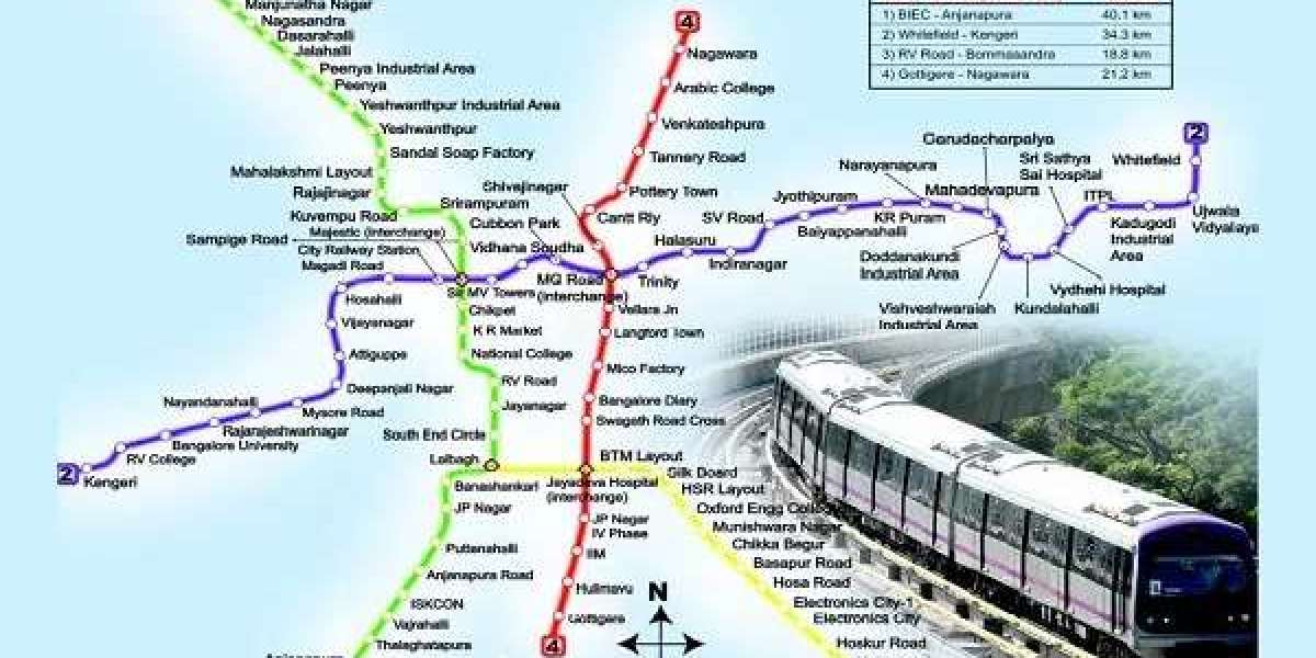
Bangalore Metro Overview
Bangalore Metro, also known as Namma Metro, is a rapid transit system serving Bangalore, Karnataka. Managed by the Bangalore Metro Rail Corporation Limited (BMRCL), it aims to decongest the city's traffic and provide a reliable transport solution. With multiple phases, the metro is continuously expanding to cover more areas.
Bangalore Metro Lines and Connectivity
Green Line
Connects Nagasandra to Silk Institute
Major Stations: Nagasandra, Peenya, Yeshwanthpur, Majestic, National College, Jayanagar, Banashankari, Silk Institute
Provides access to industrial areas, educational institutions, and residential zones
Purple Line
Connects Whitefield to Challaghatta
Major Stations: Whitefield, KR Puram, Baiyappanahalli, MG Road, Majestic, Mysore Road, Nayandahalli, Challaghatta
Crucial for IT professionals and daily commuters
Upcoming Metro Lines
Yellow Line: Connecting RV Road to Bommasandra
Pink Line: Linking Kalena Agrahara to Nagawara
Blue Line: Extending connectivity from Silk Board to KR Puram
Orange Line: Linking Hebbal to Central Silk Board
Benefits of Bangalore Metro
Reduced traffic congestion: Less dependency on road transport
Cost-effective travel: Affordable fares for daily commuters
Eco-friendly transportation: Reduced carbon footprint
Enhanced urban connectivity: Faster and more reliable transit options
Future Metro Expansions
The Phase 3 expansion will add additional corridors, improving overall accessibility. Some proposed routes include:
Sarjapur to Hebbal
Hosur Road to Marathahalli
Magadi Road to Kadabagere
Bangalore Metro Timings and Frequency
Weekdays: 5:00 AM - 11:00 PM
Weekends Holidays: 6:00 AM - 11:00 PM
Peak Hours: Every 5-7 minutes
Non-Peak Hours: Every 10-15 minutes
Ticketing System
Smart Cards: Rechargeable metro cards for frequent travelers
QR Code Tickets: Digital tickets via mobile apps
Paper Tokens: Single-journey travel tickets
Safety and Security Measures
CCTV Surveillance at all metro stations
Security Personnel stationed at entry and exit points
Womens Coaches for safe and secure travel
Emergency Help Desks available at every station
FAQs
What is the total length of Bangalore Metro?
Currently, the operational metro network spans over 73 km.
Which is the busiest metro station in Bangalore?
Majestic Metro Station is the busiest due to its interchange facility.
Is Bangalore Metro operational on weekends?
Yes, the metro operates on weekends and public holidays.
How can I check the Bangalore Metro Route Map?
The complete map is available online.
What is the fare system in Bangalore Metro?
The fare depends on the distance traveled and can be checked via official metro apps.
Does Bangalore Metro have Wi-Fi?
Wi-Fi is available at select metro stations, with plans for expansion.
Are pets allowed in Bangalore Metro?
No, pets are not allowed in metro coaches.
How can I recharge my metro card?
You can recharge online, at metro stations, or through the official metro app.
Which metro line connects IT hubs in Bangalore?
The Purple Line and upcoming Blue Line serve major IT corridors.
Are metro stations equipped with escalators and lifts?
Yes, all metro stations have elevators and escalators for accessibility.
Conclusion
The Bangalore Metro Route Map is a crucial part of the city's transportation infrastructure, ensuring seamless connectivity for residents and professionals. With continuous expansions, better technology, and improved services, Bangalore Metro is set to become the backbone of urban commuting. For the latest updates, timings, and routes, explore the official Bangalore Metro details here.


